
Hello fellow mayors, Cartographer and SimCity Level Designer Kyle Brown here back again to talk about map making. Granite Lake is the next free region map we’re releasing with Update 6, and it is a stark departure from our previous regions. Granite Lake is designed to prominently feature both mountains and a beautiful lake.
The look and feel of this region is highly inspired by the state of Colorado. And also my own personal experience – about a year ago, I landed in Denver, Colorado and was unexpectedly stranded while waiting for a connecting flight. While there, I took this picture from my hotel room:
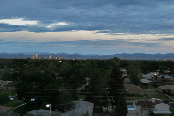
This picture probably doesn’t do justice to what I saw. But in my delirious state with only two-ish hours of sleep, it was one of the prettiest things I’ve ever seen. Famous musician and Colorado-lover John Denver wrote all of those songs about this state for a reason I guess.
When designing Granite Lake, I looked at the Mountains in Denver for inspiration. They are stacked with a range of lower mountains in front of another range of higher mountains. This was something that I incorporated into the Granite Lake region. The city plots located in the upper cluster are on a lower range and the mountains behind them are higher. The city plots on the other lower end of the lake are a little bit flatter, for those who don’t want any obstructions.
When we finished the game, we had done most of the major terrain forms; coastal, river, gorge, island, archipelago, plains, valley, and combined them in various ways. Two major terrain forms are missing from this list: mountains and lakes. Generally, when creating maps, we have removed mountains or lowered their height. Regions start out with more mountains and we pare them back. In Granite Lake, I increased the height and the amount of mountains for this region. In the other regions, we were not using the upper end of the mountain height. Granite Lake is now the tallest region we have.
Mountains play a large role in the region not only in how the region looks, but also in how it plays. There are mountains that creep into almost every city plot. The reason I did this was so mayors who like to use wind power can setup swaths of windmills along the hill sides. In the regions currently available, wind power was largely only used when starting cities and then scrapped when users could afford a better power plant. With Granite Lake, because there are higher mountains, wind power becomes more effective as the peaks create more wind in the maps. This makes wind power a better long term solution for those who choose that route to power their cities.
The other major concept of this region is the lake itself. The lake connects the clusters together. The lower cluster and the higher cluster are connected by two cities on each side. Between the mountains and the lakes, I think this region will be a nice change of pace from what is currently available.

The last thing about this map is the textures are different. As is the case with Edgewater Bay, Granite Lake got a new set of textures for the landscape.
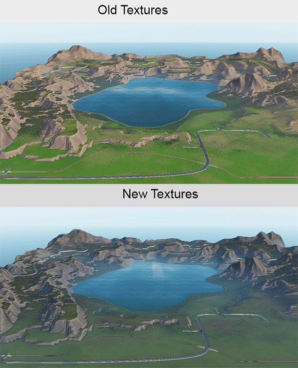
While the terrain forms are identical, the feel of each are completely different. One is a summer lake with good weather and the other is a high altitude lake somewhere that struggles to stay warm.


This Region is meant to be challenging. The city plots have multilevel terrain, but building here has its own rewards. Cities created here will have to navigate the terrain and this will cause them to become unique. These unique cities will be framed by a beautiful lake surrounded by mountains. I was striving for something scenic, maybe not as picturesque as the Denver mountains at 5:30am, but close. Looking forward to hearing what you think of this region!


0 Comments
Be the first to comment.
Welcome to Sims Community!
Our community is about connecting people through open and thoughtful conversations. We want our readers to share their views and exchange ideas in a safe space.
In order to do so, we've created a simple set of rules that will improve your experience. Simply put, keep it civil.
Your post will/might be rejected if it contains:
User accounts will/might be blocked if we notice:
So, how can you be a power user?
Thanks for reading our community guidelines. Please note that we're aware of certain issues with Sign In / Log In and Create Account / Email Confirmation issues. We're working behind-the-scenes on a new Account Creation process. Thank you for your patience and remember - freedom of speech is not freedom of reach